Photo by Ian Andrews
The Spring Heath Robberfly (Lasiopogon cinctus) does what it says on the tin – it is the first of the robberflies to emerge in spring each year, and it's found on heathlands, dunes or other sandy places. It's an uncommon species, but can be found in suitable habitats in many parts areas of Britain. it is a good one to look for in April and May, and gets you out into places that should be good for lots of other species later in the year. In 2023 the first record was on 20 April, recorded from the Merseyside sand dunes by Peter Kinsella.
Spring Heath Robberfly is quite scarce, with around 275 records on the recording scheme database. It has been recorded from 27 vice-counties altogether, but only 18 of those counties have records from the 21st century. I hope that most of the 'missing' counties are due to under-recording rather than loss, but that remains to be seen – and that is why we are running this project!
If you find this species please do add the records to iRecord, preferably with a photo if you can, or send them in to the scheme via one of the other routes. Help with identification is always available via the soldierflies Facebook group, or on iSpot.
How to recognise it
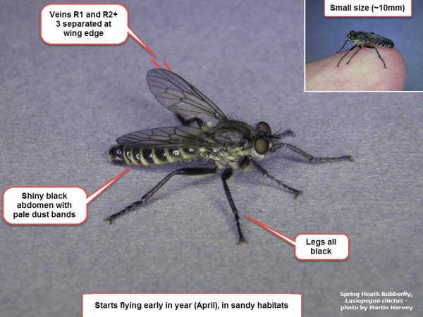
Habitat and time of year are good clues – most of the other robberflies don't start until June. Spring Heath Robberfly is small by robberfly standards (about 10mm long), and is dark with bands of yellow-grey dust on the abdomen, and more dusting on the thorax. The legs are entirely black. Adults bask on bare ground and on stones, darting out to unt for a wide range of other insect as prey. Larvae develop as predators in sandy soils. See ID guide below, and also Steven Falk's Flick collection for this species, and the European identification key by Fritz Geller-Grimm.
When to look
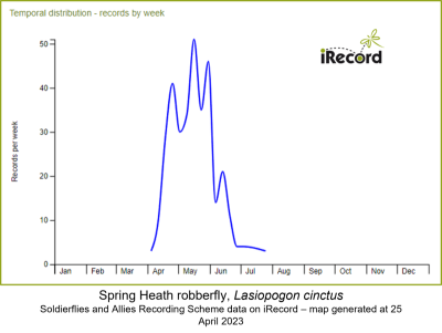
Lasiopogon cinctus flies early in the year, starting in mid-April, peaking at the end of May, and then being seen through June with even a few in July..
Where to look
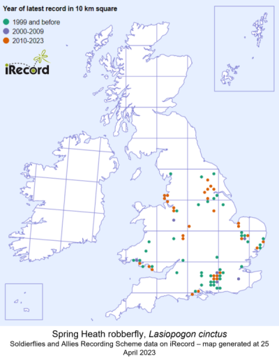
Look for Lasiopogon cinctus in any sandy heathland, dune system or other sandy habitat. Look for sheltered spots and south-facing banks with bare ground or stones for basking. Although Surrey has the greatest number of records, there are scattered sites in many counties across England and Wales, and the blank areas on the map may represent under-recording more than absence.
The map below shows all the 10km squares for which the recording scheme has records (not quite up to date with the latest records). Further records are shown on the NBN Atlas.


